Uncovering the history of Camp Blount:
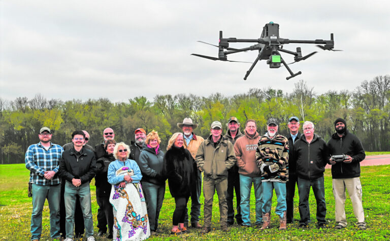
Members of the Camp Blount Historical Site Association (CBHSA) and others braved the cold wind last Monday morning while two experts from Middle Tennessee State University (MTSU) conducted a Light Detection and Ranging (LiDAR) aerial survey over Camp Blount Historic State Park and nearby areas. Two senior MTSU archeology students Matthew Schramkowski and Cody Dochnahl also traveled to Camp Blount to observe the operation.

The objective of the aerial survey was to use technology to uncover and validate three presumed historical sites, according to Eddie Hall, a CBHSA member. Hall has been coordinating with MTSU on the project.

Dr. Kevin Corns, associate professor and director of the aerospace department’s unmanned aircraft systems program at MTSU, and Daryl Hickman Jr., MTSU unmanned aircraft systems operations manager in the Aerospace Department, conducted the operation.

One site of interest MTSU and CBHSA hope to find evidence for includes the Indian and pioneer crossing or ford of the Elk River believed to be located on the west side of the Elk River Bridge where the old Stone Bridge once stood. This would hopefully show the location of the original ford across the Elk River used for hundreds of years for people to cross at a shallow place from the north side of the river bank to the south side, Hall said. Before there was a bridge or ferry, the Elk River divided Lincoln County into two almost equal parts.

“General Jackson would have had to ford the river to get to Camp Blount,” said Hall. He said 2,500 troops with wagons and horses would have gone across the ford.

Another area surveyed is to locate any signature of where the Norris Ferry landed on the south side of the Elk River. History tells us that in the early 1880s Ezekiel Norris established the first ferry across the Elk River at the mouth of Norris Creek. One of his sons, Capt. William Norris, became the owner of the ferry and ran it for a number of years, according to an article in the Fayetteville Observer on March 28, 1907. The Norris Ferry was used before the Stone Bridge was completed in the early 1860s.

“It (the mapping) will provide a full elevation site of Camp Blount,” said Hall.

The third place they hope to locate includes the original roadbed that continued from the Stone Bridge to the land on the south side of the river. If the road was used enough the initial depressions will still be there,” said Corns. “If it was a well-used road it would be sunken down.”

To begin, Dr. Corns and Hickman set up a base station which collects Global Positioning System (GPS) information and stores it on SanDisk (SD) memory cards. Hickman then launched the first drone with its own GPS to define the boundaries to be searched. The drone flew at a height of 250-feet at a speed of 23-miles-per-hour (mph) for approximately 15 minutes. When the process was completed, Hickman showed the imagery captured by the drone survey, which produced a digital color-coded map of Camp Blount’s 40 acres and surrounding area.

Later, Dr. Corns assembled a larger drone and fitted a LiDAR system to a high dollar drone. LiDAR gives us X, Y and Z coordinates, Corns said. “It allows us to colorize it.”

LiDAR mapping is a remote sensing technology. The process involves the emission of laser pulses from a LiDAR sensor towards the Earth’s surface. These laser pulses then travel through the atmosphere and interacts with the target objects, such as buildings, trees, or terrain features, according to skymaps.com. In the field of topographic mapping, Li-DAR is used to create highly detailed elevation models and terrain maps.

The data will provide a contour map. “It will show all of the lumps and bumps,” said Corns. About 900 images were captured that morning, according to Dr. Corns.

Once the mapping data is collected it is submitted to the archeologists. “It’s a multi-disciplinary effort,” Dr. Corns said. They look at it and can pull away layers of the map to eliminate the trees to get a better look at minute details, he said.

“We collect the data and the archeology department will interpret the data,” he said. The archeologists will look at minute details, said Corns. If they confirm the location, the archeologists will look at it and they would dig a trench and determine the best way to preserve it, said Corn.

Once the data is processed, Dr. Corns expects to have the survey results within a couple of weeks.

Their findings will be shared with the State of Tennessee and Camp Blount Historical Site Association, state archeologists, MTSU and the TN Wars Commission, said Hall. A large map of their findings will be created and will be used for educational purposes, said Hall. This will contribute to our understanding and appreciation of this significant site, he said.